Proposed Night-time Flying Policy | Aircraft Night Noise Assessment Report | Maps | Night Noise Contours INM Assumptions | 1 Manston Airport night noise assessment review | 2 Review of Night Quota Schemes at other UK Airports | 3 GLOSSARY OF TERMS
September 2010 | Maps | Night Noise Contours INM Assumptions | 1 Manston Airport night noise assessment review
Msftedit 5.41.15.1515;MANSTON AIRPORT
NIGHT NOISE CONTOURS
INM ASSUMPTIONS
Charles Buchanan
Manston Airport
PO Box 500
Manston
Kent
CT12 5BL
A9293-R01-AH
28/09/2010
Contents Page No.
1.0 INTRODUCTION ..............................................................................................................................3
2.0 THE AIRPORT.................................................................................................................................3
3.0 AIRCRAFT OPERATIONS ...............................................................................................................3
4.0 INM MODEL.....................................................................................................................................7
5.0 CONTOUR AREAS AND POPULATION COUNTS........................................................................10
1.0 INTRODUCTION
Bickerdike Allen Partners (BAP) have been retained by Manston Airport to determine airborne
aircraft noise contours.
Noise contours are predicted based on actual and predicted aircraft movements using the
Federal Aviation Administration (FAA) Integrated Noise Model (INM) Version 7.0b aircraft noise
prediction software. This contour methodology is recognised worldwide and is in accordance with
the methodology used for strategic noise mapping under the Environmental Noise (England)
Regulations 2006.
This document sets out the assumptions used in the computation of the night-time airborne
aircraft noise contours.
2.0 THE AIRPORT
The runway, bearing 10/28, has a (True) bearing of 101.24°, is 2752 m long and 61 m wide.
There are no displaced runway approach thresholds.
3.0 AIRCRAFT OPERATIONS
3.1 General
Aircraft movement data, supplied by the Airport, has been processed in relation to aircraft type,
departure and arrival route, stage length and runway usage to enable input into the noise
computation program, the Integrated Noise Model (INM). This section of the report describes
how this information has been compiled in a form suitable for analysis purposes and considers
the following:
· Traffic distribution by aircraft type;
· Flight tracks;
· Dispersion;
· Flight profiles;
· Traffic distribution by route.
This data has been processed into a form suitable for use with the INM model after clarifications
from the airport and assumptions made by BAP based on previous experience.
3.2 Traffic distribution by aircraft type
Details of the aircraft type and predicted annual movements in 2018 as supplied by the Airport
are given in Table 1.
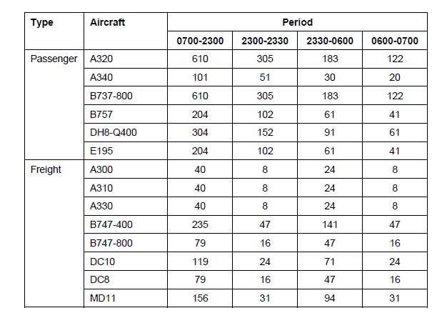
Table 1 -Annual aircraft movements by aircraft type 2018
The 8 hour night-time period is between 2300 and 0700 hours.
3.3 Flight Tracks
Flight tracks similar to a SID or a STAR are not available for the Airport. Flight tracks required for
INM noise contour generation have been developed based on information provided by the Airport
and are based on the Airport's Noise Abatement Procedures..
Aircraft departing the Runway 10 climb straight ahead until passing 4 DME where they are
directed by ATC. Aircraft departing the Runway 28 climb straight ahead to 1.5 DME where they
then turn right onto a bearing of 310º (Magnetic) until they pass 5 DME where they are then
directed by ATC.
Preliminary analysis showed that the SEL contours under consideration in this study do not
extend as far as 4 DME and 5 DME for runways 10 and 28 respectively and therefore separate
tracks have not been developed beyond these locations.
Circuits are not applicable to aircraft operating at night.
Arriving aircraft are assumed to follow the extended centre line of the runways, compatible with
the use of the Instrument Landing System (ILS).
The arrival, departure and circuit tracks have been arrived at through consultation with the Airport
and Air Traffic Control.
Arrival and departure routes are shown in Figure 1.
3.4 Dispersion
Aircraft on departure are allocated a departure route to follow. In practice, this route is not
followed precisely by all aircraft allocated to this route. The actual pattern of departing aircraft is
dispersed about the route's main track. The degree of dispersion is normally a function of the
distance travelled by an aircraft along the route after take-off and also on the form of route.
When considering many departures, it is commonly found that the spread of aircraft
approximates to a "normal distribution" pattern, the shape or spread of which will vary with
distance along the route. A simplified mathematical model can be adopted to represent a normal
distribution of events, based on standard deviations. Airport noise modelling commonly assumes
that there are five "dispersed" tracks associated with each departure route; these comprise the
Main Track of each route and the two Sub Tracks either side.
The allocation of movements adopted in this case to each track is as follows:
· 53.3% departures along the Main Track;
· 22.2% departures along each of the two inner Sub Tracks either side of the Main Track and
offset by a distance of 1.355 standard deviations;
· 1.15% departures along each of the two outer Sub Tracks either side of the Main Track and
offset by a distance of 2.71 standard deviations.
This dispersion model has been applied to a typical departure offset profile determined from data
collected at other similar airports.
The resultant dispersion scenario for all routes is shown in Table 2.
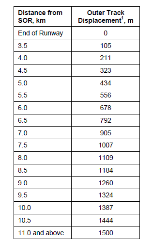
Table 2 -Assumed route dispersion
Note 1: 2.71 x Standard Deviation.
3.5 Flight profiles
For the departure movements the INM model offers a number of standard flight profiles for most
aircraft types, and in particular for the larger aircraft types. These relate to different departure
weights which are greatly affected by the length of the flight, and consequently the fuel load. In
the INM model this is referred to as the stage length and is in increments of 500 and then
1000 nm. The INM model assumes all aircraft take off with a full passenger load irrespective of
stage length. As the stage length increases the aircraft has to depart with greater fuel and so its
flight profile is slightly lower than when a shorter stage length is flown.
Stage lengths for the passenger aircraft types are given in Table 3. These are based on
destinations.
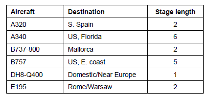
Table 3 -Passenger aircraft stage lengths
As the freight aircraft types are generally flying out empty or to destinations within 500 nm, the
stage length for all these aircraft types is 1.
3.6 Traffic distribution by route
The assumed runway utilisation for the aircraft is 33% easterly (Runway 10) and 67% westerly
(Runway 28) for both arrivals and departures for 2018. This is consistent with the runway
utilisation observed for 2009.
Aircraft movements are equally split between arrivals and departures.
4.0 INM MODEL
4.1 General
All contours and areas are determined using the Integrated Noise Model (INM) version 7.0b
software.
The Integrated Noise Model (INM) software evaluates aircraft noise in the vicinity of airports
using flight track information, aircraft fleet mix, standard defined aircraft profiles, user-defined
aircraft profiles and terrain where information is available. INM is used to produce noise exposure
contours as well as predict noise levels at specific user-defined sites.
4.2 Assumptions
Manston Airport data relevant to the INM study is taken from the latest edition of the UK
Aeronautical Information Package.
A 3.0° approach angle is used for all aircraft and the ground topography is assumed to be flat.
The INM default headwind of 14.8 km/hr and all-soft ground lateral attenuation is assumed.
Following a number of validation studies at other airports by BAP, it has been found necessary to
modify the input assumptions to better reflect actual operations and resulting noise levels for a
number of aircraft types. These are the Bombardier Dash 8 Series 400 aircraft (designatedDHC8-400), and the Embraer E195 (designated E195). Also, as the Boeing 747-800 aircraft
(designated B748) is not currently in operation and is not an available INM type, a substitution is
required for this aircraft with an assumption made of the aircraft's likely noise characteristics.
The noise characteristics of these aircraft have been adjusted by both modifying the actual
movement numbers and aircraft type. These modifications are detailed in Table 4.
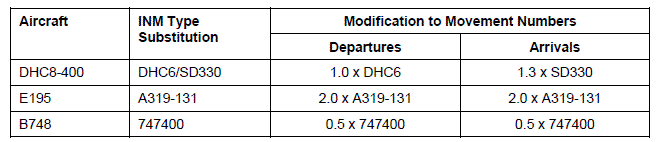
Table 4 -Modifications to INM assumptions
A summary of the aircraft types and movements numbers used in the for generation of the nighttime
LAeq,8h contours are given in Table 5. These tables summarise the resulting movements by
INM aircraft type and take into consideration those aircraft for which a substitution or modification
to the initial INM assumptions has been made and the associated INM aircraft type is given.
Details of the procedural profiles associated with each aircraft type and INM stage length can be
found in the INM 7.0b documentation.
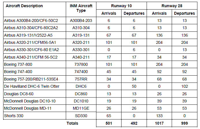
Table 5 -Aircraft types used in Night-time contours INM study (including subs. and
modifications)
5.0 CONTOUR AREAS AND POPULATION COUNTS
The areas of, and the population and dwelling numbers under, the LAeq,8h night-time contours is
given in Table 6.
Dwelling counts and population numbers have been determined from a consideration of 2009
Census data by postcode location provided by CACI Ltd.
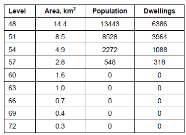
Table 6 -Areas and population, dwellings counts for night-time contours (dB LAeq,8h)
The areas of, and the population and dwelling numbers under, the SEL footprints for the
Boeing 737-800, the Boeing 747-400 and the McDonnell Douglas MD-11 are given in Table 7.
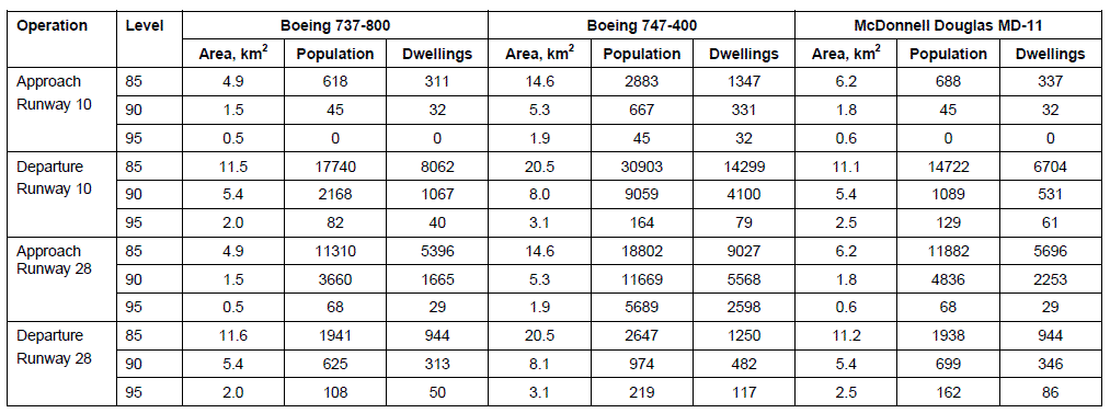
Table 7 -Areas and population/dwellings counts for aircraft noise footprints (dB SEL)